
A 911 operator in Portland, Maine, received a terrifying call Wednesday morning: Winter storm winds had just blown a truck off a bridge and into a shallow tidal basin 30 to 45 feet below.
There have been flooded residential basements and street inundation along the coastal city’s commercial area, but Donaghue said the city was spared from the worst.
Still, the massive storm that swept across the central and eastern United States left few places untouched, unleashing widespread strong winds, heavy snow and blizzard conditions, flooding rains and tornadoes. Officials have attributed at least six deaths in five states to severe thunderstorms and tornadoes and precipitation, and more fatalities could be reported. More than 400,000 customers were without power Wednesday afternoon, after half a million woke up in the dark Wednesday.
In some winters, this historically intense storm might be the one and only. But another one is forecast to come right on its heel amid an extremely active weather pattern.
As preparations begin for the next storm, here are some key impacts and statistics from the storm that just ended.
Power outages
Total power outages nationwide were about 440,000 as of 2:30 p.m. Wednesday, according to tracking website PowerOutage.us.
Florida’s Big Bend region had 2,500 outages affecting an unknown number of people as of Wednesday afternoon. Thousands of Georgians remain without electricity. First Energy reported 26,000 customers without power in Pennsylvania and New York and the same amount in New Jersey. Central Maine Power reported 303 outages affecting nearly 32,000 customers, and Versant Power in Maine had 215 outages affecting 22,000 customers. In Vermont, there were 328 outages with Green Mountain Power affecting nearly 13,000 customers and 117 outages for Vermont Electric Coop affecting 8,4000 customers.
Flooding
Numerous instances of flooding were reported from the northern Gulf Coast to New England, especially from the Appalachians and eastward. More than 500 reports of high water were received by the National Weather Service.
More than a dozen river locations reached major flood stage in the Northeast on Wednesday morning. Several rivers in Connecticut and New Jersey were near record levels. The Yantic River near Fitchville in southeastern Connecticut is under a flash flood warning for potential dam failure in the area.
A number of coastal locations and tidal tributaries in the Mid-Atlantic and Northeast also saw major to historic flooding as the storm’s winds pushed ocean water toward the shore.
This system produced the highest recorded storm surge on the Delaware River near Philadelphia, where the data goes back to 1900, at 3.97 feet above the average level of the highest tide for each day over the last 19 days, tweeted Jeff Masters, a hurricane scientist with the National Oceanic and Atmospheric Administration.
In Burlington, N.J., a gauge reached 11.99 feet, surpassing the previous record of 11.9 feet there. Annapolis reached major flooding levels from a tide more than 2.5 feet above flood stage, ranking third-highest on record.
In Maine, Bar Harbor posted its highest water level on record, while Portland observed its third highest — both about four feet above normal.
Tornadoes
The National Weather Service received a preliminary 25 tornado reports from the storm. The first was reported near Houston on Monday afternoon before a larger outbreak of the twisters on Tuesday from Florida to the Carolinas.
The year’s first fatal tornado swept through Cottonwood, Ala., Tuesday morning, causing extensive damage.
Other twisters spun inland off the Gulf of Mexico ahead of a violent squall line that generated widespread damaging winds across the southeast. Panama City, Fla., and the Florida Panhandle were hit by some of the most intense storms early Tuesday, before the coast of the Carolinas was battered later in the day.
The Weather Service issued eight tornado watches and 110 warnings, including 46 in Florida alone.
Wind
The Weather Service logged more than 2,000 reports of damaging winds between Monday and Wednesday morning from coast to coast. The damaging winds in the Pacific Northwest were tied to the next storm that is expected to explosively intensify over the central states later this week.
Wind gusts surpassing 60 mph were observed in at least 16 states east of the continental divide. Many gusts, summarized in the list below, reached at least 70 mph:
- 106 mph in Santa Rosa Beach, Fla. (probably tornado-related)
- 94 mph in Cove Mountain, Tenn.
- 90 mph in Raton, N.M.
- 78 mph in Watertown, N.Y.
- 76 mph in New River, N.C.
- 74 mph in Guymon, Okla.
- 71 mph in Brownsville, Tex.
- 70 mph in Albany, Ga.
- 70 mph in Salisbury, Md.
- 69 mph in Charleston, S.C.
- 69 mph in Burlington, Vt.
Rain
Rainfall was prolific.
Like storms that have preceded it this winter, the storm — fueled by the El Niño climate event — drew moisture from the Atlantic, Gulf of Mexico and Caribbean. Along a swath from East Texas across the South and then up the East Coast, rainfall of 2 to 3 inches was common, with some spots picking up twice those amounts. Some of the highest totals in different states are listed below:
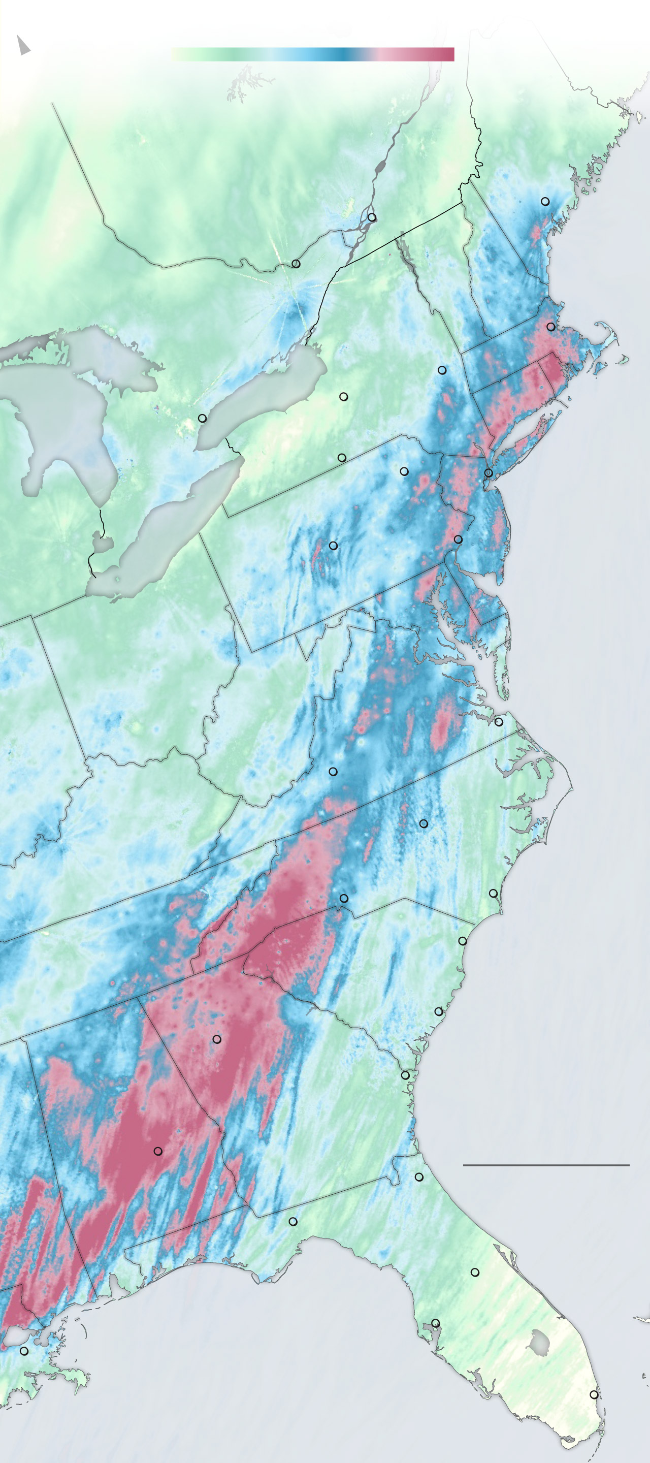
48-hour estimated rainfall
In inches as of 7 a.m., Jan. 10
NORTH
1
2
3
4
MAINE
QUEBEC
Augusta
CANADA
Montreal
U.S.
Ottawa
VER.
N.H.
ONTARIO
NEW
YORK
Boston
MASS.
Albany
L. Ontario
CONN.
R.I.
Syracuse
Toronto
Elmira
New York
Scranton
L. Erie
State
College
N.J.
Philadelphia
MICH.
PENN.
DEL.
MD.
MD.
D.C.
OHIO
VA.
VIRGINIA
WEST
VIRGINIA
Norfolk
IND.
Roanoke
Raleigh
KY.
NORTH
CAROLINA
Wilmington
Charlotte
Myrtle
Beach
SOUTH
CAROLINA
TENN.
Charleston
Atlanta
Atlantic
Ocean
Savannah
ALA.
GEORGIA
200 MILES
Montgomery
Jacksonville
FLORIDA
Tallahassee
MISS.
Orlando
Tampa
Gulf of
Mexico
New Orleans
Miami
Source: NOAA and National Weather Service
LARIS KARKLIS/THE WASHINGTON POST
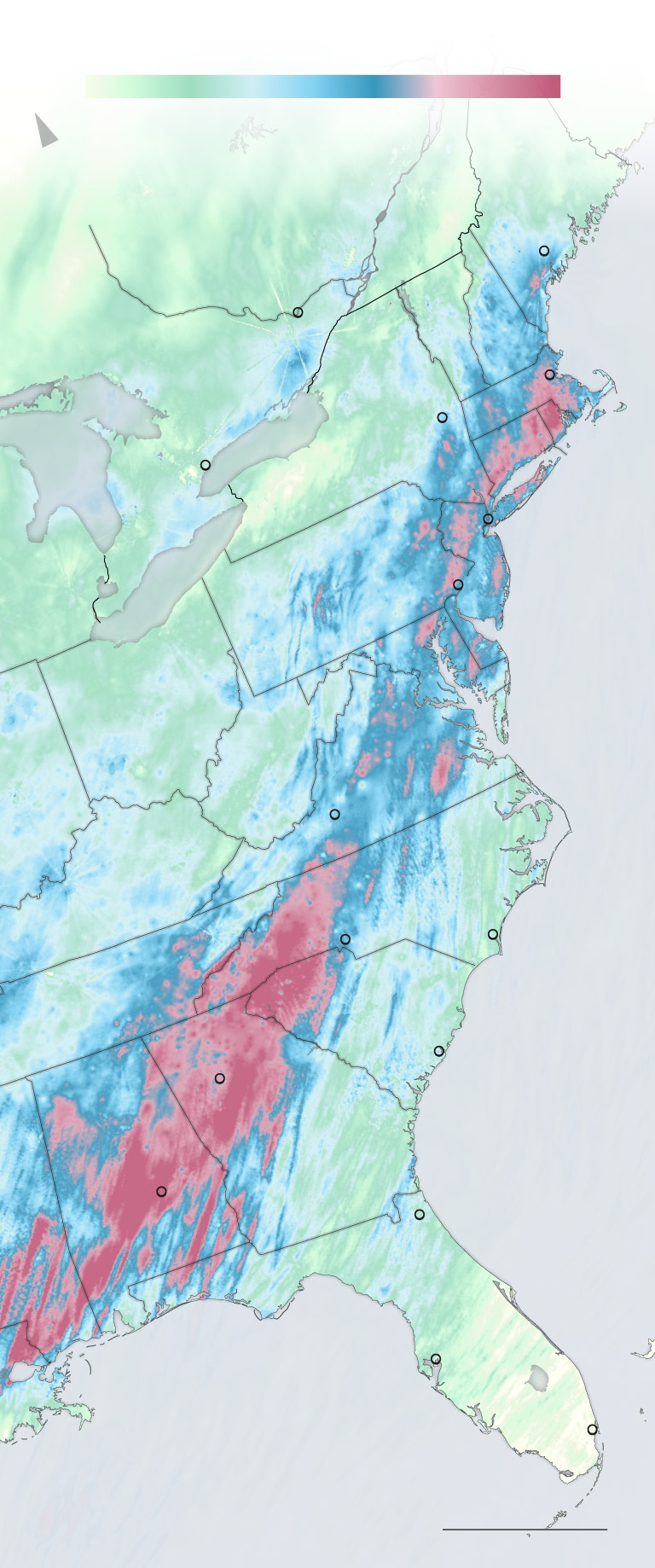
48-hour estimated rainfall
In inches as of 7 a.m., Jan. 10
1
2
3
4
NORTH
MAINE
QUEBEC
Augusta
Ottawa
VER.
CANADA
N.H.
U.S.
ONT.
Boston
N.Y.
MASS.
Albany
R.I.
CONN.
Toronto
New York
L. Erie
N.J.
Philadelphia
MICH.
PA.
DEL.
MD.
OHIO
VA.
W.VA.
IND.
Roanoke
KY.
N.C.
Charlotte
Wilmington
S.C.
TENN.
Charleston
Atlanta
Atlantic
Ocean
GA.
ALA.
Montgomery
Jacksonville
FLA.
MISS.
Tampa
LA.
Gulf of
Mexico
Miami
Source: NOAA and NWS
200 MILES
LARIS KARKLIS/THE WASHINGTON POST
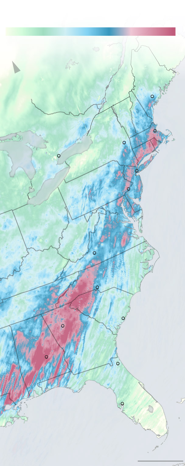
48-hour estimated rainfall
In inches as of 7 a.m., Jan. 10
1
2
3
4
NORTH
MAINE
QUEBEC
Augusta
VT.
CANADA
N.H.
U.S.
ONT.
Boston
MASS.
Albany
CT.
R.I.
N.Y.
Toronto
New York
L. Erie
Philadelphia
N.J.
PA.
DEL.
MD.
OHIO
VA.
W.VA.
Roanoke
KY.
N.C.
Charlotte
TENN.
S.C.
Charleston
Atlanta
Atlantic
Ocean
GA.
ALA.
Jacksonville
Montgomery
FLA.
MISS.
Tampa
LA.
Gulf of
Mexico
Source: NOAA and NWS
200 MILES
LARIS KARKLIS/THE WASHINGTON POST
- 5.38 inches in Montgomery, Ala.
- 4.76 inches in Athens, Ga.
- 4.68 inches in Hattiesburg, Miss.
- 4.48 inches in Waterbury, Conn.
- 4.22 inches in Greenville-Spartanburg, S.C.
- 4.10 inches in White Plains, N.Y.
- 4.09 inches in Dover, Mass.
- 3.96 inches in Mount Airy, N.C.
- 3.54 inches in Camp David, Md.
- 3.32 in Martinsville, Va.
A stripe along the East Coast has now had 8 to 15 inches of rain over the past two months. A majority of places from the Virginia and North Carolina border through southern New York and New England are having their wettest winter on record so far.
Snow
From a blizzard in the Plains to snow in northern New England, the wintry side of the powerhouse storm system also made strong impacts. The combination of snow and wind gusts over 50 mph stranded travelers and closed roads in parts of Kansas and Oklahoma while necessitating shelter-in-place orders.
An extensive zone of 6 to 12 inches was measured across much of Kansas and Iowa, as well as portions of South Dakota, Nebraska, Missouri and Illinois. Here are peak snowfall reports by state in the Midwest:
- Iowa — 15 inches in Iowa City and other locations
- Nebraska — 14.5 inches in Daykin
- South Dakota — 14 inches in Sioux City
- Kansas — 12 inches in McPherson and other locations
- Missouri — 12 inches in Linevile and other locations
- Wisconsin — 12 inches in Muscoda
- Minnesota — 11.8 inches in Hills
- Illinois — 9.2 inches in Biggsville
Other areas of moderate-to-heavy snowfall pasted the central Appalachians and the interior Northeast. Top totals by state in this region include:
- Maryland — 14.3 inches in Frostburg
- Pennsylvania — 12 inches in Ogletown
- Maine — 11.5 inches in Newry
- Vermont — 11.2 inches in Landgrove
- New Hampshire — 11 inches in Conway