Videos, photos and satellite images verified by The Washington Post show some of the places where Israeli tanks and troops appear to have advanced inside Gaza. These open-source visuals offer a window into what transpired as Gaza was plunged into digital darkness.
Israeli newspaper Israel Hayom posted a video Saturday that appeared to show Israeli troops occupying a beach hotel two miles inside the Gaza Strip. In the video, soldiers are seen holding an Israeli flag and the man recording refers to the scene as taking place three weeks after the “horrible crime,” referring to Hamas’s attack on Oct. 7. The video was geolocated by Younis Tirawi, who reports on Palestinian affairs, and later confirmed by The Post.
מרגש: דגל ישראל מונף בלב עזה🇮🇱 pic.twitter.com/5ii0xXEs74
— ישראל היום (@IsraelHayomHeb) October 28, 2023
The Israeli military shared additional video Saturday that shows armored vehicles that it said entered Gaza along the northern border. New vehicle tracks in the same area were made sometime between Thursday and Saturday, according to a comparison of satellite images provided to The Post by Planet Labs. The tracks, which are roughly a mile long, appear just north of As-Saifa in the northeast corner of Gaza, not far from the Israeli border. They are identifiable by the paths that were created or widened in the area, Jamon Van Den Hoek and Corey Scher of Decentralized Damage Mapping Group, a network of scientists who use remote sensing to map the physical impacts of conflict, said after reviewing the imagery.
More recent imagery from October 30 also shows more tracks through northern Gaza as well as some areas of significant clearing.
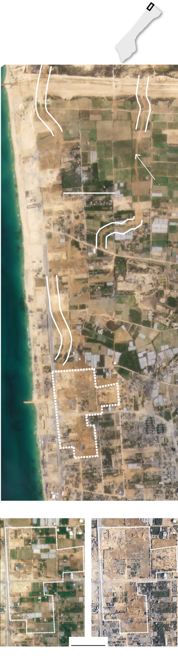
Detail
Visible changes to the
landscape over four days
in northern Gaza
GAZA
Oct. 30
ISRAEL
GAZA
Cleared
paths
since
Oct. 26
NORTH
2,000 FEET
Area with
significant
razing since
Oct. 26
Med.
Sea
Detail below
Oct. 26
Oct. 30
1,000 FEET
Satellite images © 2023 Planet Labs PBC
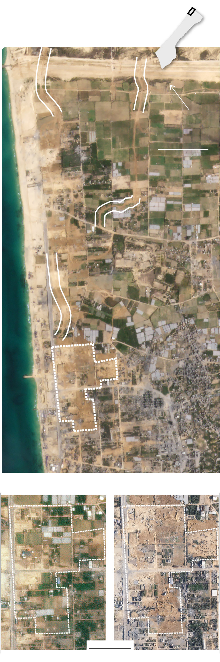
Visible changes to the landscape
over four days in northern Gaza
Detail
GAZA
Oct. 30
ISRAEL
GAZA
NORTH
Cleared
paths
since
Oct. 26
2,000 FEET
Atara
Area with
significant
razing since
Oct. 26
Med.
Sea
Detail below
Oct. 26
Oct. 30
1,000 FEET
Satellite images © 2023 Planet Labs PBC
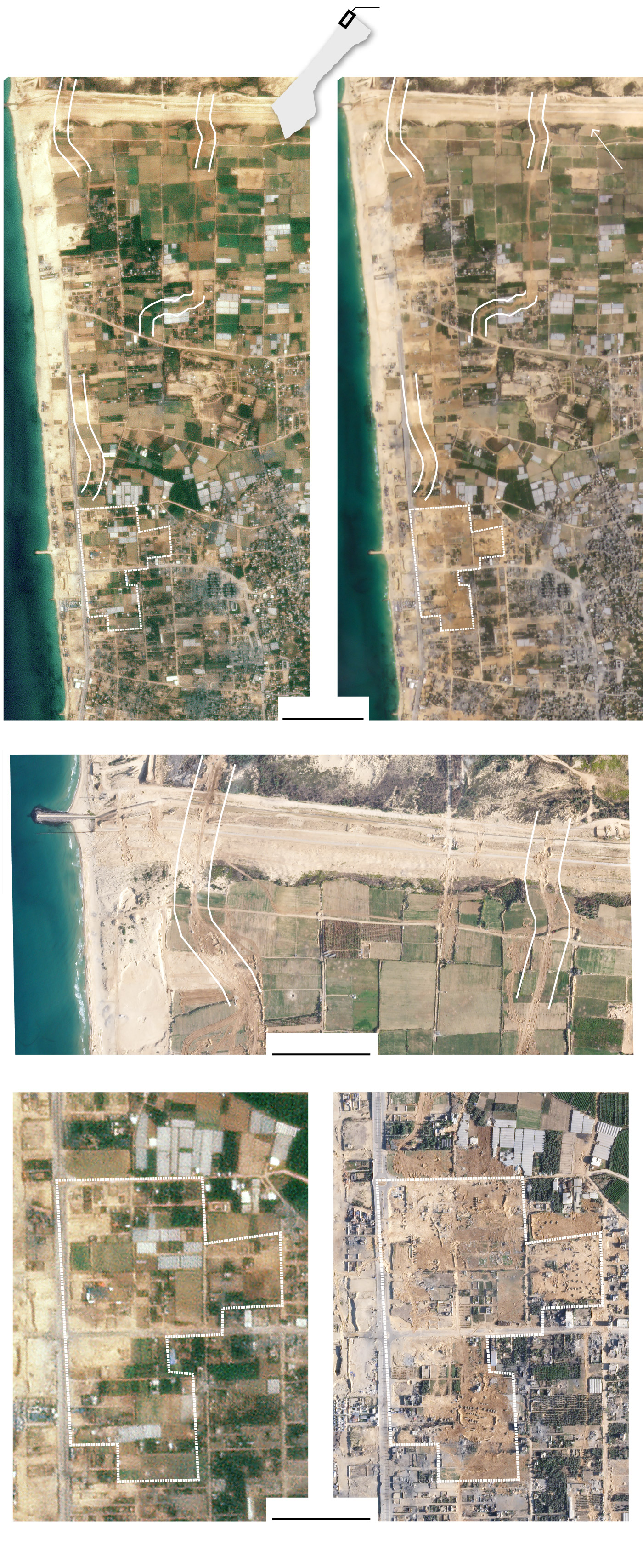
Detail
Visible changes to the landscape
over four days in northern Gaza
GAZA
Oct. 26
Oct. 30
ISRAEL
GAZA
NORTH
Cleared
paths
since
Oct. 26
Cleared
Cleared
Atara
Area with
significant
razing since
Oct. 26
Med.
Sea
2,000 FEET
Oct. 30
ISRAEL
GAZA
Med.
Sea
Cleared
paths
since
Oct. 26
Cleared
paths
since
Oct. 26
1,000 FEET
Oct. 26
Oct. 30
Area with
significant
razing
since
Oct. 26
1,000 FEET
Satellite images © 2023 Planet Labs PBC
On Monday, Palestinian journalist Youssef Saifi recorded a video that he said shows an Israeli tank firing on a civilian car on Salah al-Din Road, the main highway connecting northern and southern Gaza. Photojournalist Bashar Talib, who was with Saifi and witnessed the scene, said in an interview that they were both “surprised” to encounter an Israeli tank on the road. The Post independently geolocated the video, which shows a blast Talib said killed three people.
A spokesperson for al-Aqsa Martyrs Hospital, where the casualties were taken, confirmed the three fatalities.
Miriam Berger, Hajar Harb and Jonathan Baran contributed to this report.